EM38 Operation with the EM38-MK2 Program on Archer
Learn how to use the EM38-MK2 data logger program with the Archer Field Computer to conduct a ground conductivity survey.
The EM38 is typical used for general soil sciences and agricultural study. By measuring relatively shallow ground conductivity, the operator can determine apparent clay content, salinity, and moisture in soils which helps scientists understand more about soil content and helps farmers plant crops in the appropriate soils. The EM38 has an effective maximum depth of about 1.5 meters, or about 5 feet.

EM38 Equipment and Case
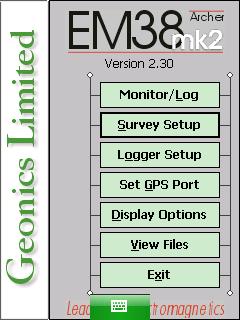
Within this course are step by step guides to each EM38-MK2 data logger menu. These menus include Survey Setup Menu, Logger Setup Menu, Set GPS Port Menu, Set Output Port Menu, Display Options Menu, Monitor /Log Menu, View Files Menu. Some basic calibration and functionality checks are included as well to ensure the user collects the most consistent and accurate data.
Instructions concerning the DAT38MK2 program are also available. The DAT38MK2 program is a computer program for the office or home computer that allows the user to view, convert, and interpret EM38-MK2 Files. Learn how to install the DAT38MK2 program and transfer files from the Archer, and convert these files into the proper post-processing file format. The DAT38MK2 cannot read EM38 data logger files without conversion. Further Dat38MK2 lessons will be added in the future to assist with post-processing.
Note: EM38-MK2 Assembly can be found in the Geonics Equipment Assembly Course.
Lessons:

EM38 Calibration and Function Tests
Battery Test The battery test should be carried out at the beginning of each day and any time the EM38 ...
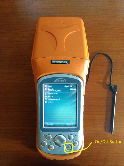
Starting the EM38-MK2 Program on Archer
Access the EM38-MK2 program on the Archer. 1. Turn on the data logger to access the EM38-MK2 program. Begin by ...

EM38-MK2 Survey Setup Menu on Archer
Configure the EM38 Survey Setup Menu on the Archer. 1. Using the stylus, select the Survey Setup Menu. EM38-MK2 Program ...
EM38-MK2 Logger Setup Menu on Archer
Configure the EM38-MK2 Logger Setup Menu on the Archer. 1. Using the stylus, select the Logger Setup Menu. EM38-MK2 Program ...
EM38-MK2 GPS Menu on Archer
Configure the EM38-MK2 GPS on the Archer. 1. Using the stylus, select the EM38-MK2 Set GPS Port Menu. EM38-MK2 Program ...
EM38-MK2 Display Options Menu on Archer
Configure the EM38-MK2 Display Options Menu on the Archer. 1. Using the stylus, select the EM31-MK2 Display Options Menu. EM38-MK2 ...
EM38-MK2 Monitor / Log Menu on Archer
1. Turn on the EM38. Perform functionality checks and null the instrument as needed. Set up the survey using the ...
EM38-MK2 View Files Menu on Archer
Configure the EM38-MK2 View Files Menu on the Archer. 1. Using the stylus, select the EM38-MK2 View Files Menu. Select ...
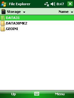
EM38-MK2 Files Transfer on Archer
Learn how to transfer EM38-MK2 files to a computer from a Archer using a SD Card. Because this option works ...

DAT38MK2 Installation
DAT38MK2 installation on a computer is an easy method to look at survey results. 1.If the DAT38MK2 program is not ...

DAT38MK2 File Opening
To open files collected on the EM38-MK2 in the DAT38MK2 files program, an EM38-MK2 file must be converted from the ...