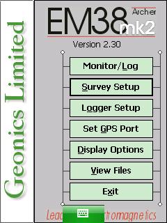
EM38-MK2 View Files Menu on Archer
Configure the EM38-MK2 View Files Menu on the Archer.
1. Using the stylus, select the EM38-MK2 View Files Menu.
The Survey Line graph screen will appear:
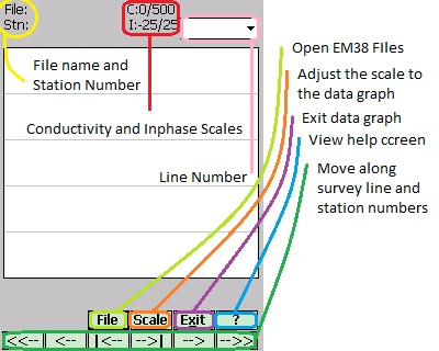
2. Click the File Button to open a file.
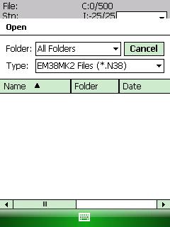
Generally, the Folder Field will display the All Folder Option. If the user wants to display files in a different folder, the directory can be changed. By default, the Type Field will read EM38-MK22 files (*.N38), meaning that only a list of EM38 files will appear. EM38-MK2 files end with the extension “.N38″.
Using the Stylus, scroll through the files to the particular file that you want to open. Double click the file to open it.
3. Once a file is open, the user may need to change its Scale.
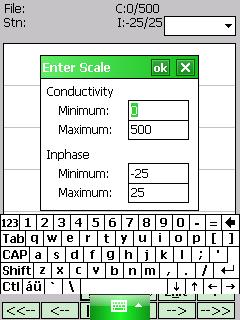
Click the Scale Button. Enter the Minimum and Maximum values for both Conductivity and Inphase. Press the OK Button to save. After saving, press the X Button to exit.
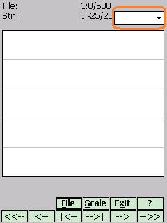
4. To change the survey line, use the Ln Field in the upper right-hand corner.
5. Navigate through the survey line using the arrow keys.
<<– : Moves the display to the start of the Survey Line.
<– : Moves the display 80 stations to the left.
|<– : Moves the vertical bar one station to the left.
–> I: Moves the vertical bar one station to the right.
–> : Moves the display 80 stations to the right.
–>> : Moves the display to the end of the Survey Line.