EM31 Operation with the EM31-MK2 Program on Archer
Learn how to use the EM31-MK2 data logger program on the Archer Field Computer in conjunction with EM31 instrumentation to conduct a ground resistivity survey.
The EM31 is typical used by geophysicists, geologists, and engineers to map soil materials, groundwater contaminants, buried metal, or any other subsurface feature that affects ground conductivity. The EM31 reaches a maximum depth penetration of about 6 meters or 20 feet.
 EM31 with a Field Computer
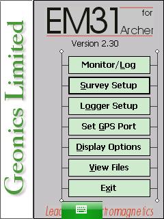
Within this course are step by step guides to each EM31-MKA data logger menu. These menus include Survey Setup Menu, Logger Setup Menu, Set GPS Port Menu, Display Options Menu, Monitor /Log Menu, and View Files Menu. Calibration and functionality checks are also included to ensure the user has a successful and accurate survey.
Instructions concerning the DAT31W program are also available. The DAT31W program is a computer program for the office or home computer that allows the user to view, convert, and interpret EM31-MK2 Files. Learn how to install the DAT31W program, transfer files from the Allegro, and convert them into the proper file format for post-processing. Further DAT31W lessons are likely to added into the future to help users with post-processing.
Note: EM31 Assembly can be found in the Geonics Equipment Assembly Course. This assembly lesson also contains initial set-up checks and instrument nulling to help the user get started.
Lessons:

EM31 Calibration and Function Checks
Disclaimer: These are general instructions based on Geonics EM31 Operating Manual and may not always apply in every situation. Ultimately, ...
Starting the EM31-MK2 Program on Archer
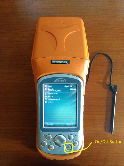
Access the EM31-MK2 program on the Archer. 1. Turn on the data logger to access the EM31-MK2 program. Begin by ...
EM31-MK2 Survey Setup Menu on Archer
Configure the EM31 Survey Setup Menu on Archer. 1. Using the stylus, select the Survey Setup Menu. EM31 Program for ...
EM31-MK2 Logger Setup Menu on Archer
Configure the EM31-MK2 Logger Setup Menu on the Archer. 1. Using the stylus, select the Logger Setup Menu. 2. Modify ...
EM31-MK2 GPS Menu on Archer
Configure the EM31-MK2 GPS on Archer. 1. Using the stylus, select the EM31-MK2 Set GPS Port Menu. 2. Select the ...
EM31-MK2 Display Options Menu on Archer
Configure the EM31-MK2 Display Options Menu on the Archer. 1. Using the stylus, select the EM31-MK2 Display Options Menu. 2 ...

EM31-MK2 Monitor / Log Menu on Archer
1. Turn on the EM31. Perform functionality checks and null the instrument as needed. Set up the survey using the ...
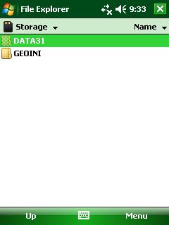
EM31-MK2 View Files Menu on Archer
Configure the EM31-MK2 View Files Menu on the Archer. 1. Using the stylus, select the EM31-MK2 View Files Menu. The ...
EM31-MK2 Files Transfer on Archer
Learn how to transfer EM31-MK2 files to a computer from an Archer Field Computer using the SD card. Because ...

DAT31W Installation
DAT31w installation on a computer is an easy method to look at survey results. 1.If the DAT31W is not already ...

DAT31W File Opening
To open files collected on the EM31-MK2 in the DAT31W files program, an EM31-MK2 file must be converted from the ...